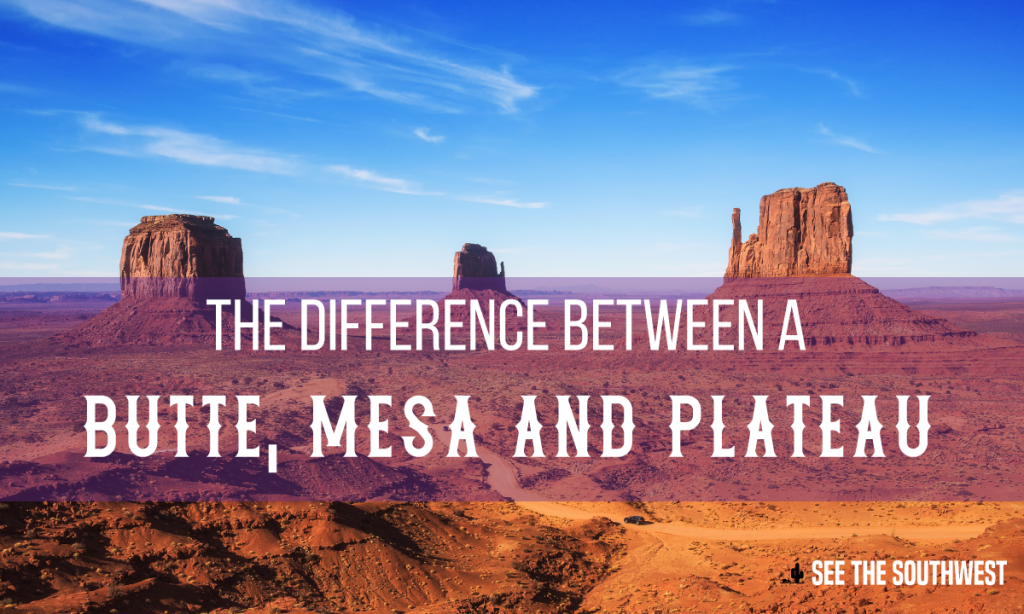
When traveling in the Southwest, you will discover plenty of the geologic and landscape features that end with the word butte, mesa or plateau — for instance, Coyote Butte, Grand Mesa, Colorado Plateau. In each instance, these geologic features have a flat top surface with relatively steep sides. So if they all have flat tops and steep sides, why aren’t they all referred to as buttes, or mesas, or plateaus?
In laymen’s terms, a butte is a small flat-topped or pointed hill or mountain. A mesa is a medium size flat-topped hill or mountain. And a plateau is a really big flat-topped hill or mountain. However, the true definitions are elegant and fascinating and encompass some of the most amazing landscape in the Southwest. Buttes are geologic features up to hundreds of feet high with steep sides, narrow pointed tops or very small flat tops. Buttes are what is left of what was once a mesa; the rest of it has been eroded away. Paria Canyon contains the spectacular Coyote Buttes Special Management Area. The notorious sandstone buttes (North and South Coyote Buttes) sit at the bottom of Utah’s Grand Staircase-Escalante National Monument and the upper section of Arizona’s Paria Canyon-Vermillion Cliffs Wilderness. The buttes and surrounding canyons contain a unique feature called The Wave, a multi-colored chute that has been cut into a sandstone mountain.
A mesa started life as a flat plain. Rivers and streams have eroded away the surrounding area, leaving a flat-topped mountain. Typically, mesas have much larger tops that a butte, and many feel that a mesa can only be called that if standing water can sometimes be found. The Grand Mesa is an outstanding example of this kind of feature. The Colorado River shaped the canyons to the north of the mesa, while the Gunnison River shaped the south side, leaving a large flat-topped mesa in between. The surface area of Grand Mesa covers more than 500 square miles.
The definition difference between a butte and a mesa most likely originated right here in the Southwest. Early settlers said that if you could find game on top, it was a mesa. Eventually that definition translated to the idea that if you could graze cattle (and find water) it was a mesa, not a butte.
A plateau is an area of land that with a relatively level surface raised sharply above the adjacent terrain on at least one side and the surface area of the top of the mesa can be huge. For example, the Colorado Plateau covers portions of southeastern Utah, northern Arizona, northwestern New Mexico and western Colorado. It covers more than 130,000 square miles (only four states in the U.S. cover a larger area). When the rest of the western United States began to rise or uplift some 10 million years ago due to continental drift, the Colorado Plateau region remained stable – perhaps “floating” on a cushion of molten rock. Though ringed by volcanic features, very few volcanoes, managed to penetrate into the interior of the plateau.
It’s handy to know these definitions when traveling the Southwest, not only for understanding how the landscape was shaped and as a reference to your current location, but also so you can appreciate the sheer magnitude of the forces that shaped some of these features.